If you are familiar with the Norwegian name Eid or Eidet, you may also be aware of the reason behind it. In Sarpsborg exists such a place.
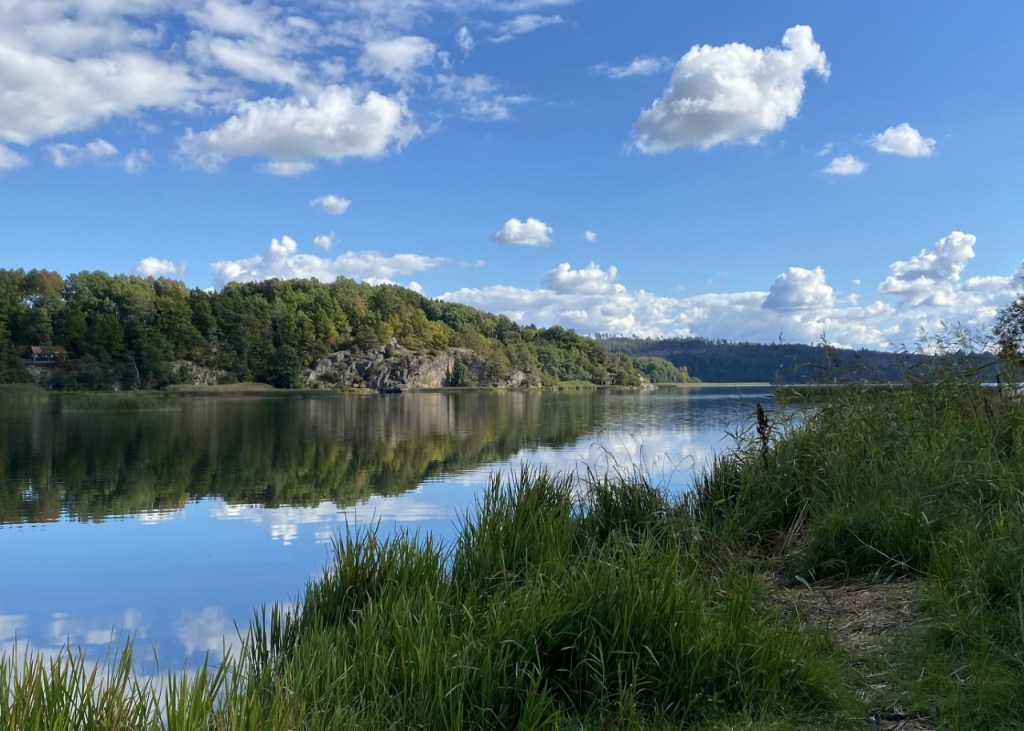
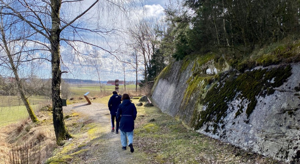
I found the subject at an old traffic junction in the local area. I’m talking about «Eidet», just below the Eidet Inn, for those who remember it. It was in the bend by the old European route E6, about one kilometre from the hospital at Kalnes, in the Sarpsborg municipality. It had a panoramic view over the Visterflo lake, a part of the Glomma delta.
Eidet tunnel with the plaquette of king Haakon VII
This tunnel was established in 1909 for floating timber from Vestvannet lake to Visterflo lake. As a result, they avoided the Sarpefossen waterfall, which represents an obstacle on the Glomma, Norway’s biggest river.
That way, they provided timber for the many sawmills downstream, all the way to Fredrikstad and the ocean.
Then I will provide you with three photos of Visterflo lake before we move to the end of this story.
Since the Viking Age, and indeed long before that, boats were taken overland, right at this spot, precisely for the same reason – to get past the rough current above and below the Sarpefossen waterfall.
So here it has been a busy traffic point for time immemorial. The ancient Norwegian «highway» to Europe. Maybe with an inn, too, for all I know.
Almost in shuttle traffic, I imagine oxen pulling Viking ships on carts on the steep hill at Eidet. Back then, Norway had hardly any roads except for the waterways. So presumably, there must have been a lot of people and activity here.
The word «Eidet» derives from eid, an isthmus, which means a narrow part of the land between two watersheds. In older days, eid meant a place where you could pull your boat over land. Many sites throughout the country still have «Eid» in their name. «Eidskog» in Hedemark is one example.
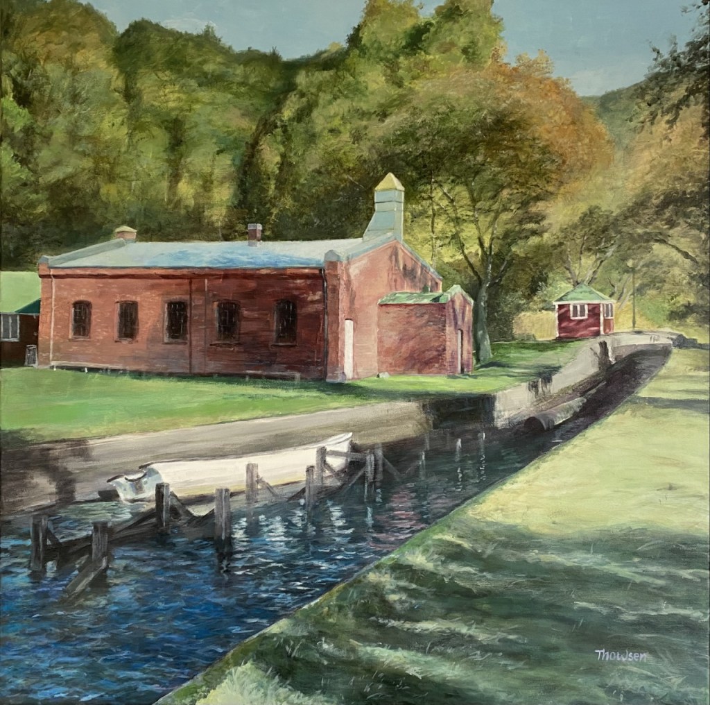
Today «Eidet» is a calm and quiet place. But its name and these buildings bear witness to its former heydays. So I just had to paint it on a canvas.
Eidet. Acrylic on canvas 80 x 80 cm
Thank you so much for your company, and please feel free to read more on my blog. You can also subscribe if you wish to follow me. Sincerely,
Europe’s largest waterfall in terms of water volume lies in Norway. The Sarp Falls has always been a mighty sight, and it has many a spectacular story to tell.
Welcome to Sarpsborg, one of the oldest towns in Norway. Founded near the Sarp Falls in 1016 AD by the king Olaf II Haraldsson, later known as Saint Olaf. Borg was built on a promontory in the river and were protected by a high defense wall.
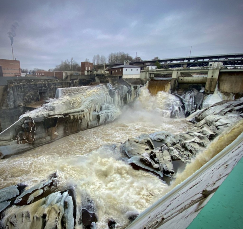
As seen in the picture above, there are tremendous forces in action. Sentenced to death, there was little chance to survive for prisoners, when pushed out into it, as imaginable.
But Sarp Falls may even had destroyed the last remains of the Viking town Borg.
More about that soon.
Calm and nice with ice, just 878 cubic metres per second. Photo: Tom Thowsen 2021
Today the industry has taken control over Sarp Falls and tamed it, mainly by the compagnies Borregaard and Hafslund. Both started as two neighboring farms on each side of the falls. Now they are two successful businesses.
Borregaard employs 1100 man-years in plants and sales offices in 16 countries throughout Europe, Americas, Asia and Africa. Has one of the world’s most advanced and sustainable biorefineries. By using natural, sustainable raw materials. Produces advanced and environmentally friendly biochemicals that can replace oil-based products. Also holds strong positions within ingredients and fine chemicals.
Hafslund Eco owns and operates hydropower plants over large parts of the country. Produces enough renewable energy to be able to supply half of all Norwegian households with electricity.
Borregaard Manor. Photo: Wikipedia
Borregaard Hovedgård is a former royal and manor house in Sarpsborg. According to the Icelander Snorre Sturlason, it was built by Olav II Haraldsson, as a royal estate. In 1312, King Håkon V gave the farm to his son-in-law Havtore Jonsson.
Although the town was moved in 1567, the manor remained here by the waterfall and the ownership of the waterfall provided opportunities for mill and sawmill operations. The last Borregaard manor, before the one pictured here, was described as a magnificent timber and half-timbered building with a tower and spire. Which sounds awesome, almost like a Norwegian Adventure. Today, the building is used as a course and representation centre for Orkla ASA—a Norwegian conglomerate operating in the Nordic region, Eastern Europe, Asia and the US.
Hafslund Manor. Photo: Wikipedia
The first known family at Hafslund were members of the Gyldenhorn family (15th century). Hafslund was a manor house of international format, located by the Frederikshald royal road to Christiania. The farm is centrally located by the old ferry resort Sandesund, and kings, cultural personalities and other great people preferred to come here on their passes. There was a lot of prestige for the owners in just this, and they were happy to invite famous people to Hafslund even though it could cost large sums of money.
Hafslund Hovedgård (Manor) has played a role as a cultural bridge-builder to Europe and has been a field of impact for art, culture and competence in the broadest sense. As crown estates, privileges and the large industrial activities, several owners have played an important role in society and politics.
The old town Borg, however, lasted for 551 years.
Then came destruction.
During the Nordic Seven Years’ War between Denmark-Norway and Sweden, the Swedes burned Borg in 1567 AD. This was not the first time, and the city’s population felt so insecure that they sought King Frederick II to move the city further out to the coast. The wish was fulfilled by King Fredrik II of Denmark-Norway, who decided to rebuild the city 14 kilometres further down the Glomma, to make it easier to defend against attacks from the Swedes. In 1567, the new city was founded at the mouth of the river. In 1569, the new city changed its name to Fredrikstad.
Back at Sarp Falls, only a small village remained among the medieval ruins.
Sarpsfossen Painting by Erik Pauelsen (1749–1790)
In this painting from 1789, the crater appears like a valley on the other side of the river.
On the night between 14 and 15 February 1702 at Borregaard farm, they wanted a midwife. The lady on the farm was about to give birth. When the midwife came, she saw that the field had cracked, and the barn was about to collapse. The farmers and their servants were notified, and a hasty evacuation began. Gathered on the safe ground west of the farm, they realised that they had left the animals behind. They have only managed to save an iron chest with some silver and some documents. While the lady was rowed over to Hafslundsøy and taken to Hafslund manor, and the servants tried to rescue the animals, the crack suddenly widens up, and it all slid out into the river. Fifteen people and nearly 200 animals died in the landslide, which had a length of 380 meters and a maximum width of 340 meters. Large parts of the old town were also gone.
Was it Sarp Falls to blame?
Due to Quick Clay, this kind of natural catastrophes occurs in old glacial terrain in Canada, Norway, Russia, Sweden, Finland, the United States, and a few other locations. The clay is so unstable that when a mass of quick clay is subjected to sufficient stress, the material behaviour may drastically change from that of a particulate material to that of a watery fluid. Landslides occur because of the sudden soil liquefaction caused by external solicitations such as vibrations induced by an earthquake, or massive rainfalls.
Today’s Sarp Falls is developed according to all the rules of engineering art. But sometimes, however, it will show itself in its former glory. The last great flood was in the early summer of 1995. Then ministers stood with worried expressions on their faces and experienced what hydropower can be at its most dangerous – and most magnificent way. Roaring and shaking the ground.
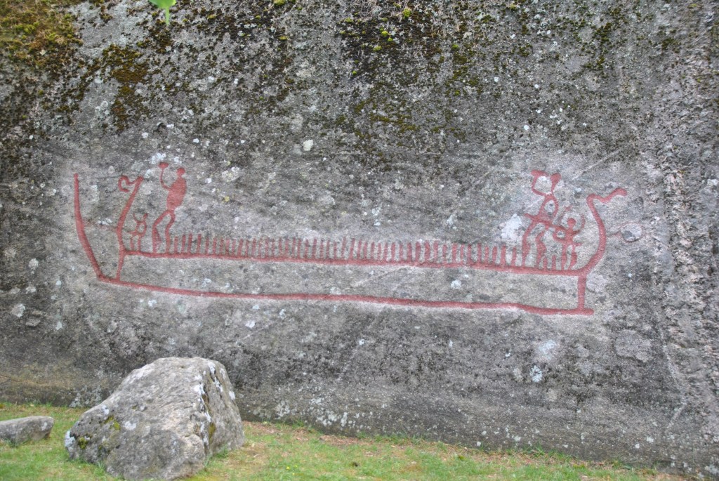
With its 4 x 1,5 meters, this is probably the largest of its kind in Northern Europe. Its location is in South-eastern Norway. Today the rock is lying in the farm fields. At the time the carving was created, around 3000 years ago, this was a coast.
Photo: Thomas M. Hansen
A ship like this was 20 meters long and crewed by 24 warriors. On calm water, it could do 8 knots, 3,5 on the open sea. A crossing from Denmark to Norway could take 18 hours.
At this time, 2000 years before the Vikings, our ancestors had horned helmets. The Vikings had none.
Photo: Tom ThowsenThe farm fields in Skjeberg, in the vicinity of the carving. Three thousand years ago, most of this was beneath the sea. Photo: Tom Thowsen